
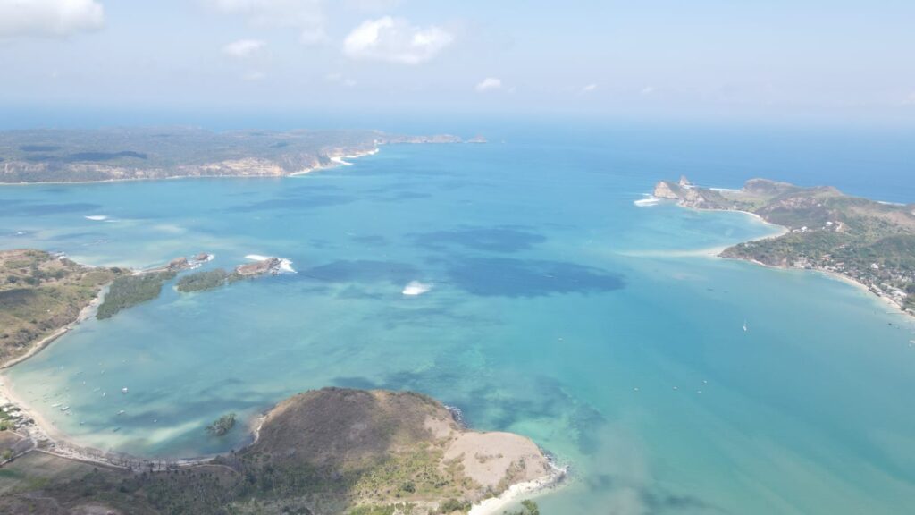
Coast guide South Lombok
Within an hour of Kuta you can reach calm swimming bays, hilltop viewpoints and some of Lombok's best-known surf beaches.
Kuta in South Lombok, not to be confused with Kuta in Bali, sits at the centre of a coastline of bays separated by green headlands. The town is the base for the Mandalika area and its race circuit, and most visitors use it to explore the beaches on either side. This guide works outwards from Kuta, first to the east and then to the west, with notes on swimming, surf and access.
Kuta and the Mandalika beachfront
The main beach in front of Kuta has white sand, clear water and reefs offshore. It is the easiest beach to reach on foot from town, with cafes and places to rent boards. Along the Mandalika beachfront, the sand is soft and the water sheltered, and the setting is quieter, with green hills behind and fishing boats passing.
East of Kuta
Serenting and Seger
Serenting lies just before Seger, with blue water and larger waves that draw surfers. Seger is about 15 minutes from Kuta Beach and around 30 minutes by road from Lombok International Airport. It is known among surfers, has a small entrance fee, and is the setting for Bau Nyale, an annual tradition in which crowds gather on the shore to catch nyale, a type of sea worm. Local belief holds that the nyale are the reincarnation of Putri Mandalika, a princess in Sasak legend who sacrificed herself to keep the peace. The date is set each year by the traditional Sasak calendar, usually in February or March. A statue of the princess stands near the beach, and Bukit Seger, a short walk up the hill, gives a wide view of the curved Mandalika coastline at sunset.
Tanjung Aan
Tanjung Aan is about 20 minutes east of Kuta. It has two bays of white sand made up of coarse coral grains, with calm, shallow water that suits swimming and snorkelling. Surfing is possible further out. The drive passes farms, villages and coconut groves, and the beach is a popular place to watch the sunset.
Bukit Merese and Tanjung Bongo
Bukit Merese is the grassy headland beside Tanjung Aan. A walk to the top, which is not steep, gives one of the best-known views on the south coast. On the far side lies Tanjung Bongo, reached by walking over the hill. It is quiet, with a wide beach, clear water and a natural pool among the rocks that is good for bathing. Small parking fees apply.
Gerupuk
Further east, Gerupuk is a fishing village on a large bay with several surf breaks. Most of them are reached by local boat from the village. Surfers of different levels use the bay, and boatmen know which break suits the day's swell.
West of Kuta
Mawun
Mawun is a horseshoe-shaped bay between Kuta and Selong Belanak. The edges under the hills are shallow and calm, while the centre is deeper with stronger waves, so swimmers with children usually stay near the sides. The hills beside the beach give views over the Indian Ocean and the neighbouring bays.
Mawi
Mawi lies between Mawun and Selong Belanak, about 45 minutes west of Kuta. It is a white-sand bay surrounded by hills and is popular with intermediate and experienced surfers. It is at its best in the dry season.
Selong Belanak
Selong Belanak is a long, curved beach and one of the most popular on the south coast, especially during the June to August holidays. It is a common place for surf lessons, with traditional bamboo and thatch stalls along the sand. Even on busy days the beach is long enough to find space.
Semeti and beyond
Further west, Semeti has white sand and unusual rock and coral formations, and is used for fishing, snorkelling and surfing. Beyond it the coast continues towards Torok and Nambung, where the road becomes quieter and development is still sparse.
Two easy day plans
East loop: start early at Tanjung Aan for a swim while the water is calm and the beach is quiet. Walk up Bukit Merese before the midday heat, cross to Tanjung Bongo if you want a quieter spot, then have lunch in Gerupuk. Come back by way of Seger for the late afternoon and watch the sunset from Bukit Seger.
West loop: drive to Selong Belanak in the morning for a surf lesson or a long walk on the sand. Continue to Mawi to watch experienced surfers, then stop at Mawun on the way back, where the calm edges of the bay are good for a late swim.
Either loop works on a scooter, but a car with a driver is more comfortable for families and on the steeper roads to the west.
When to go
The dry season, roughly from May to October, brings the clearest water, firmer roads and the most reliable surf. It is also the busiest period, especially in July and August. The wet season, usually from November to March, turns the hills green and brings fewer visitors, but afternoon rain can make some access tracks slippery. Bau Nyale at Seger falls in this wetter part of the year.
Practical tips
- Getting around: most beaches are reached by scooter or car from Kuta. Roads have improved around Mandalika, but some access tracks are steep or rough.
- Currents: the centres of open bays can have strong rip currents. Swim near the edges, watch where local people swim, and do not swim alone on quiet beaches.
- Fees: many beaches charge a small entrance or parking fee, collected by the village. Carry small notes.
- Reef and sun: wear reef shoes on rocky sections and protect yourself from the sun in the middle of the day.
- Respect: dress modestly when you leave the beach and pass through villages, and ask before photographing people.
For land buyers: what the coast means
The beaches are a large part of why people look at land in South Lombok. When you compare plots, consider the distance to the beaches your guests or family would actually use, the drive to Kuta and the airport, and how the Mandalika area's development may change traffic and services nearby. Beachfront land is subject to coastal setbacks that limit where you can build, so check them early. Our Mandalika land checklist and our guide to evaluating beachfront land cover the questions to ask.
Visitor note: Entrance fees, access roads and beach facilities change, particularly as the Mandalika area develops. Ask locally for current conditions.
Sources
- Wonderful Indonesia: 10 wonderful beaches in Mandalika
- Good News From Indonesia: Seger Beach and the Mandalika legend (February 2026)
Property examples to compare
Plots along this coastline include 3.28 Ha Beachfront Land in Kuta Mandalika, 1.65 Ha Land near Mandalika Circuit and Tanjung Aan and 5.8 Ha Beachfront Land at Torok Beach. Ask our team how far each plot is from the beaches you care about.
Looking for land near these beaches?
Tell us which part of the coast you prefer. We will share listings in that area and the access details to check on a visit.
Editorial note: Visitor information on this page was checked in November 2026. Conditions, fees and access change. Follow local advice on swimming and surf safety.
